


US Topo Maps
US Topo Maps leírása
Könnyen használható kültéri navigációs alkalmazás ingyenes hozzáféréssel az Egyesült Államok legjobb elérhető térképeihez és légifelvételeihez.
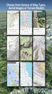
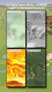
Válasszon 30+ térképréteg közül (topók, antennák, tengeri térképek stb.) a tökéletes utazás megtervezéséhez és
alakítsa Andoid telefonját/táblagépét kültéri GPS-vé, hogy offline utazásokat tegyen a távoli országokba.
Egyszerűen hozzáadhat térképeket más forrásokból (GeoPDF, GeoTiff, online térképszolgáltatások, például WMS stb.)
Az USA-ban elérhető alaptérkép-rétegek:
• USGS National Map Topo
• USGS National Map Imagery Topo
• USGS National Map Imagery
• USGS NAIP HiRes Imagery
• USGS Topo hagyományos DRG-k: Az USA topotérképeinek zökkenőmentes lefedettsége 1:250.000, 1:100.000, 1:63.000 és 1:24.000/25.000 léptékben
• FSTopo Forest Maps
• NOAA tengeri RNC diagramok
• Nemzeti domborzati térképek (Hillshade, Slope Map, Aspect Map)
Világméretű alaptérkép rétegei:
• OpenStreetMaps (5 különböző térképelrendezés), helytakarékos vektorformátumban is letölthető
• Google Térkép (műholdas képek, út- és domborzati térkép)
• Bing térképek (műholdas képek, útiterv)
• Föld éjjel
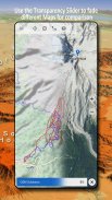
Konfiguráljon egy alaptérkép réteget fedvényként, és használjon átlátszósági fadert a térképek zökkenőmentes összehasonlításához.
Térképek hozzáadása más forrásokból:
• Raszteres térképek importálása GeoPDF, GeoTiff, MBTiles vagy Ozi formátumban (Oziexplorer OZF2 és OZF3)
• Webes térképészeti szolgáltatások hozzáadása WMS vagy WMTS/Tileserverként
• OpenStreetMaps importálása Vector formátumban, például teljes USA-ban néhány GB-ért
Elérhető egyesült államokbeli térképlefedések – további információk hozzáadása bármely más alaptérképhez:
• Közterületi tulajdon (PAD-US 3)
• Nemzeti vízrajzi adatkészlet
• Gépjárműhasználati térkép (USDA)
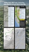
• Magassági körvonalak
• 4WD pályák
• Pályák
• Utak, vasutak, repülőterek
Világszerte elérhető lefedések:
• Dombárnyékoló rátét
• 20 m-es körvonalak
• OpenSeaMap
Nincs tökéletes térkép. Váltson a különböző térképrétegek között, vagy használja a térképek összehasonlítása funkciót a legérdekesebb útvonal megtalálásához. Különösen a régi hagyományos DRG-k tartalmaznak sok kis útvonalat vagy egyéb olyan funkciót, amely hiányzik a modern térképekről.
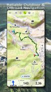
A kültéri navigáció főbb jellemzői:
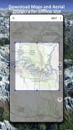
• Töltse le a térképadatokat az OFFLINE HASZNÁLATHOZ
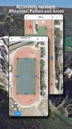
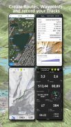
• Mérje meg az útvonalakat és a területeket
• Útpontok létrehozása és szerkesztése
• GoTo-Waypoint-Navigation
• Útvonalak létrehozása és szerkesztése
• Útvonal-navigáció (pont-pont navigáció)
• Nyomvonalrögzítés (sebesség-, magasság- és pontossági profillal)
• Tripmaster kilométerszámláló, átlagsebesség, irányszög, magasság stb. mezőkkel.
• GPX/KML/KMZ import/exportálás
• Keresés (helynevek, POI-k, utcák)
• Szerezzen magasságot és távolságot
• Testreszabható adatmezők a Térképnézetben és a Tripmasterben (pl. sebesség, távolság, iránytű stb.)
• Útpontok, nyomvonalak vagy útvonalak megosztása (e-mailen, Dropboxon, WhatsApp-on stb.)
• Használja a WGS84, UTM vagy MGRS/USNG (Military Grid/US National Grid) koordinátáit,
• Műsorszám visszajátszása
• és még sok más ...
Használja ezt a navigációs alkalmazást szabadtéri tevékenységekhez, például túrázáshoz, kerékpározáshoz, kempingezéshez, hegymászáshoz, lovagláshoz, síeléshez, kenuzáshoz, vadászathoz, motorosszán túrákhoz, terepjáró 4WD túrákhoz vagy keresés és mentés (SAR).
Adjon hozzá egyéni útpontokat hosszúsági/szélességi, UTM vagy MGRS/USNG formátumban a WGS84 adattal.
Importálhat/exportálhat/megoszthat GPS-útpontokat/nyomvonalakat/útvonalakat GPX vagy Google Earth KML/KMZ formátumban.
Tekintse meg az animált NEXRAD esőradart, hogy pontos előrejelzéseket készíthessen, mikor kezdődik/áll el az eső
Kérjük, küldje el kérdéseit, megjegyzéseit és funkcióigényeit a support@atlogis.com címre
US Topo Maps - APK információ
APK verzió: 7.7.2Csomag: com.atlogis.northamerica.freeUS Topo Maps legújabb verziója
Egyéb változatok


Appok ebben a kategóriában


